Location-enabled mobile search and guidance system
Thematic areas
Smart, Sustainable, Connected and Shared mobility
Summary
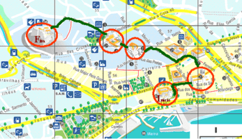
The service implemented and provided supports pedestrian/ soft-modes navigation for city-walks to points of interest, providing related/ contextual multimedia information about each point of interest or attraction. Provision of location/ geographic based information is accessible via web, both for handhelds/ smartphones and desktop/ laptop computers. Design, editing and publishing of personal itineraries/ walks is also possible.
Implementing sustainable mobility
Funchal (MT) developed and tested/evaluated a pilot project for a location-enabled mobile guidance system via Global Positioning System (GPS) technology. The application is targeted at both tourists and residents, who can access the service through smart phones or desktops. Through localisation the system helps pedestrians find walking routes and can guide their city- walk. It can also lead them to attractions and provide multimedia information when the user reaches a point of interest.
The main objective of the measure were to:
- Objective 1: Support to pedestrian navigation for routes to visits (or city-walks) to points of interest with related/contextual multimedia information about each point of interest or attraction;
- Objective 1.1: Provision of location/geographic based information accessible via web, both for handhelds/smartphones and desktop/laptop computers;
- Objective 2: Design, editing and publishing of personal/favorite itineraries / walks;
Integrated mobile and desktop web access is available at http://routes.inmadeira.com. Specific mobile applications for Android and iPhone may be downloaded from Google Play and Apple App Store.
Progress
Being a pilot project, this measure was very successful considering that it consisted of the development, implementation and promotion of a pilot service/project for creating and publishing walks/routes, preferably to be performed on foot or using public transport. The electronic guiding service uses GPS and follows a social-media approach in the sense that end users may also contribute. The service is called "Funchal Routes". Once created and published, a walk can be printed on paper or downloaded to a mobile phone (Android or IPhone).
Outcomes
Integrated mobile and desktop web access is available at http://routes.inmadeira.com. Specific mobile applications for Android and iPhone may be downloaded from Google Play and Apple App Store.


