3D LiDAR Sidewalk Scanner
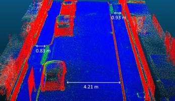
Image by International Federation of Pedestrians
Basic Information
Latest update
Price
Free
Tool type
Serious game MUSE
Application area
- Data gathering
- Evaluation and monitoring
Target Audience
- Rural areas
- Small cities
- Medium-sized cities
- Large cities
- Metropolitan regions
Summary
The 3D LiDAR Sidewalk Scanner is a mobile, low-cost digital tool that captures high-resolution data on sidewalk width, slope, surface condition, obstacles, and accessibility using laser-based scanning technology. It enables cities, researchers, and community groups to generate precise, actionable evidence to improve walkability, support inclusive urban design, and strengthen pedestrian-focused mobility planning.
Good Example
EALLOCATE Project Pilot cities: Zagreb, Bologna, Utrecht, Heidelberg, Lyon, Budapest, Gothenburg.
Contacts
Lead of the tool development: REALLOCATE
alan.raposo [at] ifpedestrians.org


