New Circulation Plan implemented in Porto
Porto has implemented a circulation plan for the Asprela quarter considering all modes of transport in a comprehensive transport planning perspective.
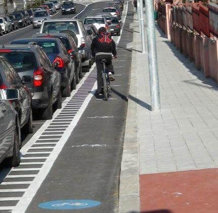
The main objective of the Asprela Circulation Plan was to change the mobility and improve accessibility of the Asprela quarter. The approach took land use, environmental and operational issues into account. The finalised plan proposed specific measures to be implemented. It addressed the road network, public transport network, pedestrian network, bicycle network, traffic management, traffic safety, as well as parking policy and control. The infrastructure works were developed in three main streets of the CIVITAS area. On Dr. António Bernardino de Almeida Street, the main actions focused on: Public lights and a water drainage system (it was necessary to reconstruct the public lights and drainage system due to a road dividing the location of the two systems); Increasing and regulating the width of footpaths (to improve pedestrian accessibility); # New pavements and cycle lanes (one of the most important ways to implement sustainable local mobility and promote a new mentality among inhabitants); and Traffic signs and improvements at an intersection through a roundabout. The intersection had a track record of accidents involving pedestrians. In order to increase road safety a roundabout was designed and some traffic safety behaviour techniques were applied. This also permits to easily implement other improvements brought forward in the plan that were not taken into account this time. On Dr. Plácido Costa Street, the arrangement of parking spaces was improved to spots parallel to the street to make space for a cycle lane. The main activities in this area were: A new cycle lane: The cycle lane is one way, has a width of 1.5 m and runs along the entire street. It has a width of 1,5 m and is equipped with traffic signs. The cycle lane is already open to the public. On Dr. Roberto Frias Street, besides the introduction of the cycle lane and traffic lights, an extra lane was created to reduce the congestion on the Júlio Amaral de Carvalho Street. The main activities developed on this street were: A new cycle lane: It is one way, 1m wide and runs along the entire street. It includes traffic signs and traffic lights. The traffic lights on the intersections Roberto Frias/ Plácido Costa/ Frei D. Vicente de Soledad e Castro were implemented in the first week of January 2012. They have a specific sensor on the bus corridor which gives priority to public transport. The street has a dedicated bus lane. When the bus arrives at the intersection it touches an electromagnetic sensor in the road. This releases a unique and exclusive green phase for the bus vehicles. All other traffic lights turn red at the intersection and only the bus is permitted to pass. Pavements are lowered to street level at crossings to improve pedestrian mobility. Pavements and crossings have been marked with a specific texture to help visually impaired people to keep orientation.


