Bologna uses google maps for real time traffic monitoring
The Municipality of Bologna has recently signed an agreement with the Italian division of the well-known internet search engine, in order to make available in real time in Google maps information concerning the traffic monitoring of Bologna. The data are processed in real time directly by the Mobility Control Centre based in the Municipality’s offices.
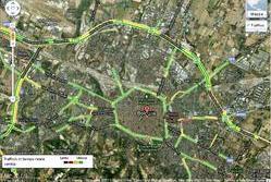
So far, the data was available for internal use only. Now everyone can get free access by using google maps. The service has been working since 15 December. By clicking on “traffic” the map of the city will be red, yellow or green coloured, according to the traffic situation of the different areas (hoping to have the more roads green!).Bologna is one of the first Italian cities to adopt this service, which was available only to the world’s largest cities. This service marks an important step forward towards a larger diffusion of information concerning the traffic.
Author: Mauro Borioni


