
Valletta Region (Malta)
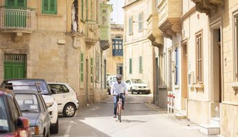
Malta can be considered an island with one main urban area (the Valletta Region). The Valletta Region developed from the agglomeration of a number of towns and villages, each with their own centre, which have grown into a continuous urban area. This spatial distribution of town centres in Malta, and the comparison between the extent of urban fabric and pedestrian catchment areas, can trigger a significant potential for walking as a viable and convenient option for daily access to facilities such as health centres, schools, groceries, and other services. In comparison to the other DESTINATIONS sites, the mobility features of the island mostly resemble that of an urban area. Out of all the sites, Malta is the most densely inhabited area with the greatest population density per kilometre. Car ownership rate is the highest (763/1.000 inhabitants) and there is no seasonality in tourism. The mobility challenges are typical of a dense urban area, where around 74% of trips are made by car, whereas only 11% of trips are made by public transport. Bicycle use is also relatively low.
In recent years, tourism has been increasing year-on-year with a 5,2% increase just between 2018 and 2019. In 2017, there were 2.314.596 inbound tourists, 2.633.919 in 2018 and 2.771.888 in 2019.This in turn continues to congest roads that are already operating at capacity. While private car ownership and usage is on the increase, public transport patronage has, after many years of decline, seen an encouraging positive trend in patronage.
Fast Facts
493,559
Population
Projects

Knowledge Bank


News & Events


Partners


